A Powerful Earthquake Strikes Russia: Understanding the Pacific-Wide Tsunami Alert
On a seemingly ordinary Wednesday, the earth dramatically reminded us of its immense power when an 8.8 magnitude earthquake erupted off Russia’s far eastern coast near the Kamchatka Peninsula. The seismic event, one of the strongest ever recorded, sent shockwaves across the Pacific, triggering widespread tsunami warnings and mobilizing emergency responses in multiple countries.
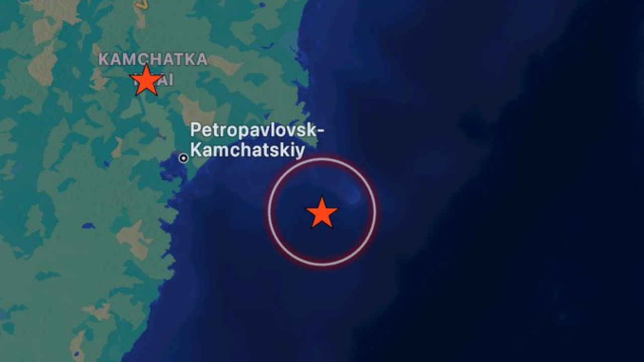
The earthquake struck at approximately 11:25 local time, centered 119 kilometers east-southeast of Petropavlovsk-Kamchatsky. Initially reported as an 8.0 magnitude event, it was quickly revised upward, ultimately ranking as the sixth most severe earthquake in history. To put this into perspective, it stands alongside historic earthquakes in Chile (2010) and Ecuador (1906), though still below the devastating 2004 Indian Ocean earthquake that claimed over 227,000 lives.
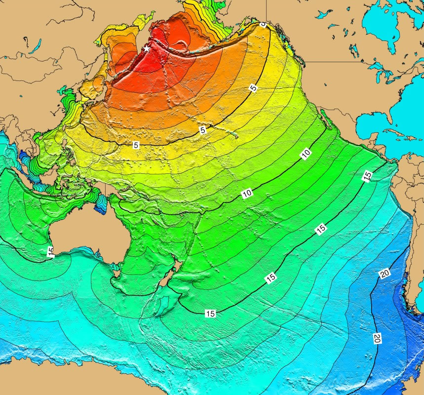
What made this event particularly remarkable was its global reach. Over two million people across diverse regions found themselves under tsunami alerts, including Japan, Hawaii, the United States west coast, China, the Philippines, Indonesia, New Zealand, Peru, Chile, and Mexico. The potential for widespread destruction loomed large, yet the region’s unique geographical characteristics played a crucial role in mitigating potential catastrophe.

In Russia’s Severo-Kurilsk, the impact was most visible. Four-meter waves flooded a port and fish processing facility, sweeping vessels from their moorings and causing localized damage. The Sakhalin region experienced power grid disruptions, though tsunami warnings were eventually lifted. Japan faced similar initial concerns, with approximately 1.9 million people urged to evacuate to higher ground—a precaution that was later downgraded as the threat diminished.
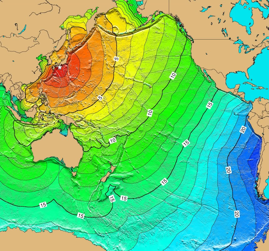
Scientists tracking the event provided fascinating insights into tsunami dynamics. Helen Janiszewski from the University of Hawaii explained that tsunami waves travel at speeds comparable to jet planes, reaching North America’s west coast around 12:20 local time—approximately eight to nine hours after the initial earthquake. Chris Goldfinger, a marine geology professor, emphasized that impact varies significantly based on location-specific factors and the earthquake’s energy radiation.
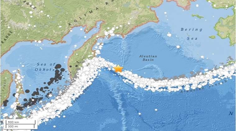
The Kamchatka region’s geological history adds another layer of intrigue. It previously experienced the world’s first recorded magnitude 9 earthquake in 1952, highlighting its seismic volatility. This recent event even evoked memories of the 2011 Fukushima nuclear disaster, prompting immediate evacuations at the Fukushima plant.
Remarkably, despite the earthquake’s immense power, immediate casualties were minimal. The region’s low population density likely contributed to this outcome, a stark contrast to densely populated areas like Sumatra during the 2004 disaster. While several injuries were reported, no immediate fatalities were confirmed.
As tsunami warnings gradually transformed into advisories, authorities continued to urge vigilance. Scientists remained actively engaged, refining predictive models and monitoring potential aftereffects. The event served as a powerful reminder of our planet’s dynamic nature and the importance of preparedness, communication, and scientific understanding in mitigating natural disaster risks.
For residents and observers across the Pacific, this earthquake was more than just a geological event—it was a testament to the complex, interconnected systems that shape our world, demonstrating how a single seismic moment can ripple across thousands of miles, touching countless lives in its wake.