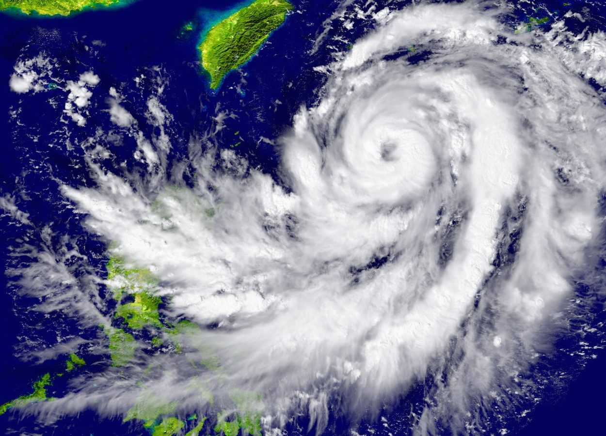
Tropical Cyclone Formation and Track
A low-pressure system is currently sitting over the central and northern parts of the South China Sea. This system is expected to grow stronger and turn into a tropical cyclone today. After forming, it will move toward the seas south of Hainan Island. This development is happening because of warm ocean water and the right wind conditions in the area, which help tropical cyclones form. The path of the cyclone is guided by larger weather patterns, like winds high in the sky, pushing it in this direction. Meteorologists are keeping a close eye on it to predict any changes in its track or strength.
Weather Impacts: Southern China and Coastal Regions
The tropical cyclone, combined with a high-pressure ridge over southeastern China, will bring rough weather to the northern South China Sea and the coast of southern China. Expect windy conditions, a few showers, and squally thunderstorms today and tomorrow. Squally thunderstorms mean sudden, strong winds and heavy rain that can come with lightning. There will also be swells, which are big waves in the sea that can be dangerous for boats. The areas most affected will be the northern South China Sea and the southern coast of China, especially near Guangdong. The winds and rain could be strong in some spots, so people in these areas should be ready for bad weather.

Weekend Improvement and Subsequent Weather Disturbance
As the tropical cyclone moves away, the weather along the coast of Guangdong should get a little better over the weekend. The winds and rain will calm down some. However, early next week, another weather system called an upper-air disturbance will move in. This will bring more showers to Guangdong. Luckily, by the middle and later parts of next week, a high-pressure system called an anticyclone will take over. This should bring mostly clear and fine weather to southern China, giving the region a break from the rain and storms.
Regional Weather Breakdown
Different areas will see different weather because of this tropical cyclone and the systems that follow. In Guangdong, along the coast, expect windy weather with gusts up to 40-50 kilometers per hour (25-31 miles per hour) and heavy rain at times, especially today and tomorrow. Hainan Island, closer to where the cyclone is heading, might see stronger winds and heavier rain, along with rough seas and swells up to 2-3 meters (6-10 feet) high. In the northern South China Sea, marine conditions will be dangerous for small boats due to high waves and strong winds. Each area will feel the impact differently, so it’s important to check local updates for the latest information.

Safety Guidelines and Preparations
If you live in or are visiting southern China, take steps to stay safe during this weather. Secure loose items outside, like patio furniture, so they don’t blow away in high winds. Avoid going near the sea or beaches because of rough waves and swells. Be ready for possible flooding by keeping important items off the floor and knowing where to go if water rises. Listen to weather updates on the radio, TV, or online to know if the storm gets worse. Have an emergency kit ready with water, food, a flashlight, and batteries just in case. Staying informed and prepared can keep you and your family safe.
Economic and Maritime Implications
This tropical cyclone could cause problems for people who work on the water or along the coast. Fishing boats may need to stay in port because of rough seas and swells, which means less fish to sell. Shipping companies might face delays as they avoid dangerous areas in the South China Sea. Coastal businesses, like shops or restaurants near the beach, could see fewer customers or even damage from wind and rain. It’s very important for anyone working on the water to check weather reports often and follow safety rules to avoid accidents during this stormy time.
Long-term Forecast and Climate Context
Tropical cyclones are a normal part of the weather in southern China, especially during the warmer months. This area often sees several cyclones each year, usually between May and November. This current storm might be one of the first of the season, and it could mean more are coming. If this turns into an active cyclone season, it could bring more rain, wind, and damage to the region over the next few months. Scientists watch these patterns to understand if the weather is changing over time due to bigger climate shifts. For now, staying ready for each storm is the best way to handle whatever comes.
Conclusion and Final Weather Outlook
To wrap up, a tropical cyclone is forming in the South China Sea and will bring windy weather, showers, and rough seas to southern China today and tomorrow. Things should get a bit better along the Guangdong coast over the weekend as the cyclone moves away. However, more showers are expected early next week due to another weather system. By the middle to end of next week, fine weather should return. Keep checking weather updates and stay prepared for any sudden changes. Being ready is the best way to stay safe during this stormy time.