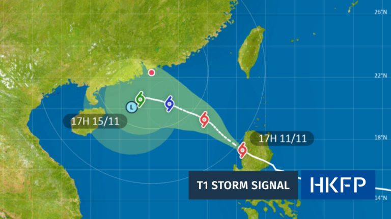
Overview of the Weather Situation
The weather in Southern China is about to change due to two big weather systems. A ridge of high pressure is sitting over southeastern China, and it will make the weather better tomorrow. At the same time, a broad area of low pressure is forming over the central to northern parts of the South China Sea. This low pressure might move toward Hainan Island and the coast of western Guangdong in the next few days. These two systems working together will cause different weather effects, like wind and rain, in the region.
The Ridge of High Pressure
A ridge of high pressure is like a big bubble of heavy air that pushes bad weather away. Right now, it’s over southeastern China. This system is strong and will bring clearer skies and nicer weather to the area tomorrow. High pressure usually means less rain and more sunshine because it stops clouds and storms from forming. So, expect a break from rainy days in this part of China for a short time.
The Broad Low Pressure System
Meanwhile, a broad area of low pressure is starting to form over the South China Sea, in the central and northern parts. Low pressure is the opposite of high pressure—it often brings clouds, rain, and storms. This system might move slowly toward Hainan Island and the western coast of Guangdong over the next couple of days. Right now, we’re not sure if it will turn into a tropical cyclone, which is a big, spinning storm. Weather experts are watching it closely to see what happens.
Combined Weather Effects
When a high pressure ridge and a low pressure system are near each other, they can create strong winds. That’s what’s happening along the coast of southern China and the northern part of the South China Sea. The difference in air pressure between these two systems makes the air move faster, causing windy conditions. If you’re near the coast or on the water, be ready for stronger breezes in the coming days.
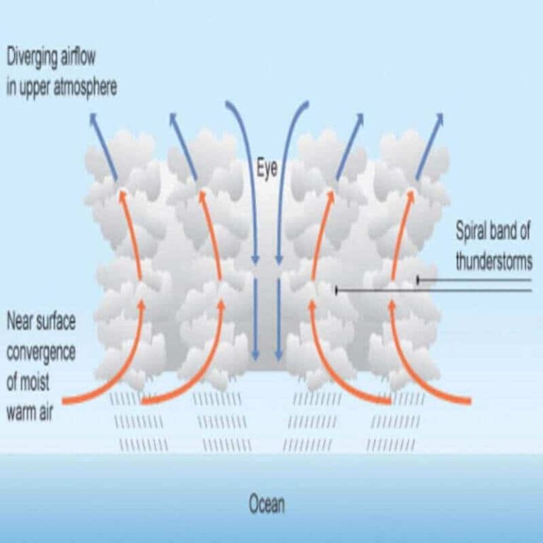
Heavy Squally Showers and Thunderstorms
Early next week, the weather will get rough in some areas. Heavy squally showers, which are sudden bursts of rain with strong winds, are expected. Thunderstorms will also happen over southern China and nearby waters. These storms could be intense, with loud thunder, lightning, and a lot of rain in a short time. If you live in or are visiting this region, stay updated on weather warnings and avoid being outside during these storms.
Easing of Showers
As the week goes on, the broad low pressure system will move inland and start to weaken. When this happens, the heavy showers along the coast of Guangdong will calm down. By the middle and later parts of next week, you can expect less rain and fewer storms. The weather should start to feel more settled, though it’s still a good idea to check forecasts for any last-minute changes.

Temperature and Humidity Trends
Temperatures in Southern China will vary over the next few days. During the day, highs might reach around 30-33°C (86-91°F) when the high pressure brings clearer skies. At night, lows could drop to 25-27°C (77-81°F). Humidity will stay high, especially near the coast, making it feel sticky and warm. When the low pressure brings rain early next week, temperatures might cool a bit, but humidity will still be noticeable.
Wind Conditions
Winds will be stronger near the coast and over the South China Sea due to the clash of high and low pressure. Expect winds coming mostly from the east or southeast at speeds of 20-30 km/h (12-18 mph). On higher ground, like hills or mountains, winds could be even faster, reaching up to 40 km/h (25 mph). Offshore areas might see gusts during storms early next week, so be careful if you’re on a boat or near the water.
Sea and Soil Temperature Data
Sea temperatures near North Point are currently around 28-29°C (82-84°F), which is warm enough to help fuel storms if the low pressure strengthens. Soil temperatures at the Hong Kong Observatory, measured at different depths, show surface levels at about 30°C (86°F), while deeper soil is slightly cooler at 28°C (82°F). Warm sea and soil can add more heat and moisture to the air, which might make storms stronger in the coming days.
Regional Weather Progression
Here’s a day-by-day look at the weather from Saturday, Aug 16 to Sunday, Aug 24:
- Aug 16 (Sat): Improving weather in southeastern China due to high pressure. Mostly sunny with warm temperatures.
- Aug 17 (Sun): Still nice in many areas, but low pressure starts forming over the South China Sea.
- Aug 18-19 (Mon-Tue): Low pressure moves closer to Hainan Island and Guangdong. Winds pick up along the coast.
- Aug 20-21 (Wed-Thu): Heavy squally showers and thunderstorms hit early in the week. Stay indoors if possible.
- Aug 22-23 (Fri-Sat): Low pressure weakens as it moves inland. Showers start to ease off along Guangdong’s coast.
- Aug 24 (Sun): More settled weather, with fewer showers and lighter winds.
Implications for Regional Activities
These weather changes will affect daily life in Southern China. If you have outdoor plans, like picnics or sports, the nicer weather on Saturday and Sunday might be a good time. But early next week, heavy rain and storms could make it unsafe to be outside. If you’re near the coast, strong winds might affect fishing or boating. Make sure to listen to local weather updates and take precautions, like carrying an umbrella or staying indoors during storms. Farmers and travelers should also plan around the rainy days to avoid problems.